
Fort Lee Previous Residents Across Eras
A backward address search has separate evidence for a property, a household, and a building’s physical history. The current address starts the trail, but the source should change with the era. Bergen’s online land index documents recorded instruments from 1970 forward. Older deeds, historical maps, library holdings, and archives take over before that point. Printed Fort Lee and reverse-directory year runs were not verified in the public research, so they should be requested from a reference desk rather than assumed.
| Source | Years it covers | Where held | What it can show |
|---|---|---|---|
| Bergen online land index | January 1, 1970 to present | Bergen County Land Records Search | Recorded deeds, mortgages, parties, dates, legal identifiers, and images where available. |
| Fort Lee borough-era records | From March 29, 1904 | Borough, County Clerk, and historic sources | Fort Lee jurisdiction; older searches may need Ridgefield Township or section names. |
| Fort Lee Sanborn maps | 1908, 1911, 1923, and 1930 | Princeton University digital collection | Building footprints, construction material, use, and street or site context. |
| Federal census | Public through 1950 | NARA 1950 Census | Household composition at the enumeration date; an enumeration district may be needed. |
| Printed and reverse directories | Exact Fort Lee runs unverified | Fort Lee Library, State Library, and regional holdings | Possible address-to-name, telephone, or business listings after a volume is confirmed. |
| Permits and code files | No online series verified | Fort Lee Building Department or OPRA | Address, work type, applicant or owner, and inspection timing if releasable. |
Use the land index first for a modern transfer. Use Sanborn maps when the question is when a building form appeared. Use the census and a confirmed directory volume when the question concerns a past household. A permit request can date a change to the structure, but it is not a complete resident list.
Fort Lee Parcel Cards Start Backward
For a backward Fort Lee address search, copy the current parcel facts before searching names. The Fort Lee Tax Assessor and county-linked property search are the practical entry points. Record the current owner, situs address, mailing address, block, lot, PAMS_PIN, tax classification, and any assessment or sale clue actually displayed. The Bergen parcel viewer can add a mapped boundary, municipality, QCODE, and LASTUPDATE. These fields keep a later deed or map search tied to the right piece of land.
The address on a tax bill may not be the physical Fort Lee parcel. A mailing location can belong to a fiduciary, lender, business, or owner elsewhere. The situs address is the physical location used by maps and address-keyed municipal records. A mailing field is therefore a trail clue, not proof that a person occupied the property. The legal description, block, and lot are more dependable when an old address has a different spelling or section label.
Note: Preserve each identifier exactly as displayed, including punctuation and qualification codes, before moving into the deed chain.
Trace Fort Lee Previous Residents Deeds
A deed chain follows ownership backward, not every person who may have lived at the address. Search the current owner as grantee in the Bergen County land-record index, then open the document detail or image where the record makes one available. The seller on that deed is the grantor. Search that seller as grantee in an earlier date range to locate the prior purchase, then repeat. Search both party roles because an earlier owner appears as a grantor when selling and as a grantee when buying.
- Pull the Fort Lee parcel’s current owner, situs address, block, lot, and legal description from the assessor or GIS record.
- Search the owner as a grantee, using Fort Lee, the date range, paired party, block/lot, or document type to narrow the result.
- Open the purchase document and record the grantor, grantee, recorded date, instrument number or book/page, consideration if shown, legal description, and prior-reference language.
- Search that grantor as a grantee in an earlier period. The prior deed identifies the next transaction to examine.
- When the trail reaches the online cutoff, move to the County Clerk’s books and indexes, State Archives land material, historical society collections, or a library-supported request.
- Grantor and grantee
- The grantor transfers an interest. The grantee receives it in the recorded document.
- Chain of title
- The linked sequence of recorded transfers for a parcel, followed from one transaction to an earlier one.
- Legal description
- The block, lot, map, plat, or other formal land description that can remain useful when an address changes.
- Criss-cross directory
- An address-to-name directory, if a confirmed library volume contains the relevant Fort Lee period.
- Enumeration district
- The census area used to locate households when a name index is difficult or an address is known.
The Bergen land-search help documents Party Name, Second Party Name, More Names, ALL/ANY logic, wildcarding, date and municipality filters, plus F2 detail and F5 image controls.
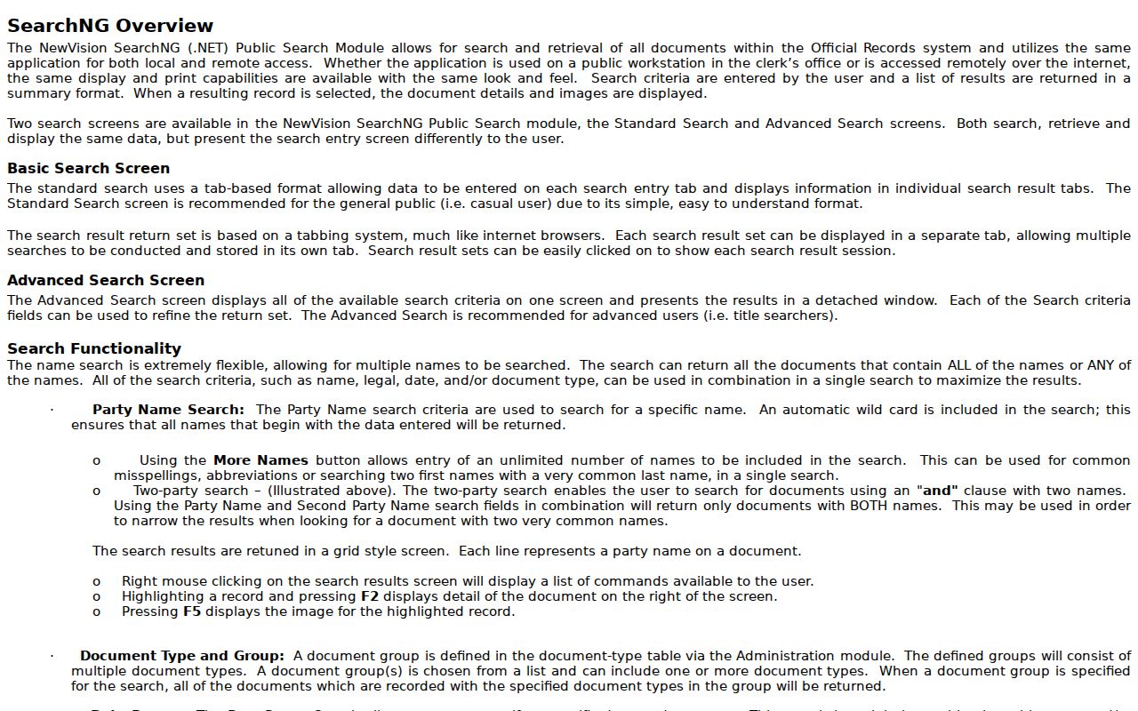
Use spelling variants and paired parties rather than treating an initial or spelling difference as proof of a different person. The documented controls help narrow a common surname without inventing a live result format the research did not capture.
Fort Lee’s 1970 Index Handoff
The most important practical limit in the Fort Lee backward-address trail is the online portal’s January 1, 1970 boundary. It is not a complete chain back to the borough’s origin. When the linked deeds reach that date, shift to Bergen County Clerk office research, deed books, State Archives holdings, Bergen County Historical Society material, or a library request. The switch is normal and should be recorded as part of the search log.
Earlier property research may also use different geographic names. Fort Lee was formed from the remaining portions of Ridgefield Township on March 29, 1904. A pre-borough record can be under Ridgefield Township, Village of Taylorville, Coytesville, Palisades, or another local section label. Compare block, lot, legal description, and the old map context before carrying a modern address backward. No official boroughwide street-renumbering year was found, so no such date should be assumed.
Fort Lee Previous Residents on Sanborn
Sanborn maps answer a different question from a deed. They show the built setting around an old Fort Lee address: footprint, construction material, use, street or site context, and fire-insurance detail. Princeton’s digitized series includes Fort Lee sheets from 1908, 1911, 1923, and 1930. The 1911 catalog separately identifies Fort Lee and Coytesville sheets, while the 1923 material includes a Palisades context. That is useful when an address was described by a section name rather than the current borough label.
Start with an index sheet, identify the relevant street or site, and compare the selected map with the parcel’s legal description and later records. A building footprint can support a date range for a structure change. It cannot identify every past Fort Lee resident. A permit trail, directory listing, census schedule, or obituary may supply a person or household connection that the map itself cannot.
Fort Lee Households in Census
Past occupants who were not owners need a parallel household trail. Ask Fort Lee Public Library staff to check a confirmed city, telephone, reverse, or criss-cross directory by year, address, publisher, and shelf code. Preserve the spelling, initials, street notation, and volume date as printed. The public research did not confirm exact Fort Lee directory runs, so the reference request should also ask about regional Englewood and Northern Valley titles, newspapers, obituaries, yearbooks, and local-history shelves.
- Choose a verified directory year close to the deed or map date and note the address, person, and volume details exactly.
- Check nearby available years for an address change, a new name, or a changed household notation without silently merging similar names.
- Pair the date with the public federal census years of 1900, 1910, 1920, 1930, 1940, or 1950. The directory issue date and census date may not match.
- Use an enumeration district or address approach if the census name index is difficult, then test the result against the parcel and deed trail.
- Use obituaries, cemetery or church records, probate, or Fort Lee school and funeral-home material as corroboration, not as an unsupported identity match.
The Fort Lee Public Library’s services include public computers, scanning, copying, Wi-Fi, and in-person research-help channels.
Bring the address, former names, likely period, block and lot, map-sheet reference, and known deed dates. Those details let a reference question stay focused even when an exact local directory run has not been published online.
Fort Lee Previous Residents Before 1904
People from an earlier Fort Lee address may disappear from a modern-name search simply because the borough did not yet exist. The 1904 formation date directs older searches toward Ridgefield Township and named local sections. The County Clerk’s Fort Lee historic material also identifies a Village of Taylorville map filed in 1853 and a Pond Park at Fort Lee Village map filed in 1864. These names can be added to an archive or historical-society request when a current street cannot be matched directly.
The New Jersey State Archives adds older land, tax, vital, probate, naturalization, court, and newspaper material. Its historical vital holdings include births through 1925 and marriages and deaths through 1950 under archive rules. Bergen tax-ratable records provide still earlier property and taxpayer clues for county-area research, but they belong to pre-borough geography. Keep a written note of the jurisdiction used for every result so a Ridgefield or village record is not incorrectly labeled as a later Fort Lee address.
Limits on Fort Lee Previous Residents
A prior owner, an old directory listing, and a census household are different forms of evidence. None alone proves a complete succession of people at a Fort Lee address. A deed documents a recorded transfer. A directory may reflect a business, mailing location, or one listed person. A census records a household on its enumeration date. Records can be missing, offline, sealed, redacted, or indexed under a variant name. State Archives, the County Clerk, the local library, and the historical society are the right fallback channels when the public web trail stops.
New Jersey protections also matter. The Address Confidentiality Program and Daniel’s Law can suppress qualifying or covered people’s information, and voter, motor-vehicle, court, juvenile, victim, family, and sealed-record rules may restrict public display. Do not try to bypass a protected address with another database or republish sensitive identifiers found in a recorded image.
The Fort Lee city directory collections page has the collection-focused context for a confirmed historical volume. Keep the address trail separate from that broader shelf research.
Lawful use. Fort Lee house-history research is for family history and personal curiosity. Do not use a record to harass, stalk, intimidate, or track a living person.